Statistical data is registered by area (including all of Japan) in e-Stat. Statistical LOD of Japan uses Statistical standard area code, small area code and grid square code as area code. An area is defined as one of dimensions.
- Statistical standard area code
- Small area code, grid square code
Statistical standard area code
Outline of statistical standard area code
Statistical LOD of Japan provides Statistical standard area code and related municipality information such as abolishment, absorption and name changes since April 1970 as well as statistical data.
What is statistical standard area code?
Statistical standard area code is a standard for region code of municipalities and its mutual use. Based on the statistics council, it is established in April 1970. Since then, each time when area of municipalities is changed by reason of absorption and so on, standard area code is revised.
In 1968, Ministry of internal affairs and communications (at that time "ministry of home affairs") set area code of prefectures and municipalities as "local government code". Standard area code follows the "local government code" and also covers area code of sub-prefectures and districts.
Codes of prefectures and municipalities are standardized by JISX0401 and JISX0402 respectively, standard area code is the same as JISX0401 and JISX0402.
Number of digits of standard area code (five digits)
- 1st and 2nd digits show prefectural code.
- 3rd through 5th digits show municipality code. "000" means prefecture.
Examples
00000 All area
01000 Hokkaido
01100 Sapporo-city
01101 Sapporo-city chuo-ward
01330 Oshima sub-prefecture
For more details refer to "http://www.soumu.go.jp/toukei_toukatsu/index/seido/9-5.htm" (in Japanese)
* "local government code" has 6 digits. The 6th digit is check digit and 1st-5th digits equal to standard area code.
Absorption or separation of municipalities
The following municipality information since April 1970 is stored.
- Establishment of new municipality
- abolishment
- Separation
- Division into several municipalities
- Absorption
- Changes of names
- Shift to designated city
- Changes of boundaries
Definition of statistical standard area code
Codes for representing area and related information
Area is defined as dimension. Area information consists of "standard area code" entity and "reason for change" entity.
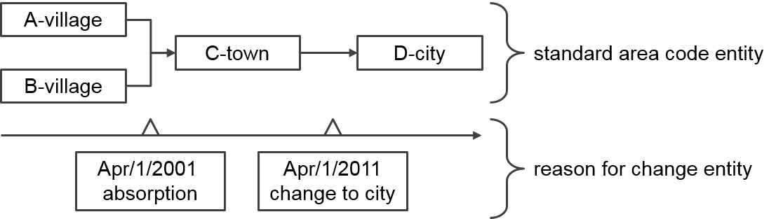
Standard area code has validated period because of absorption or separation of municipalities. In the above example, while A-city and B-village had existed until March 31, 2001, they have not existed after April 1, 2001. C-town had existed from April 1, 2001 to March 31, 2011.
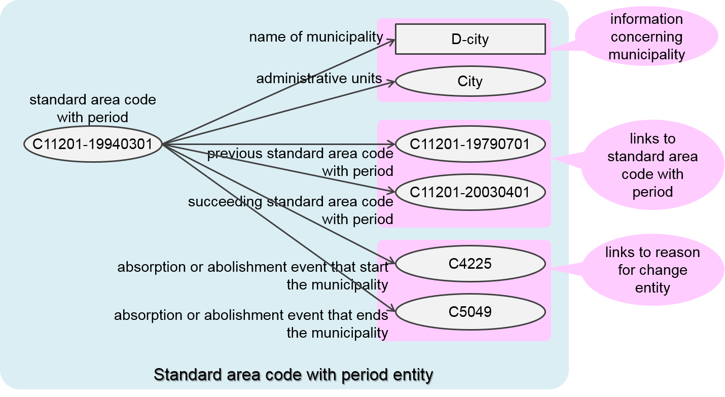
Standard area code entity changes to another entity on the boundary of the effective date of absorption or separation. The entity is called "standard area code entity with period". Standard area code with period is represented by the format <standard area code>-<effective date>.
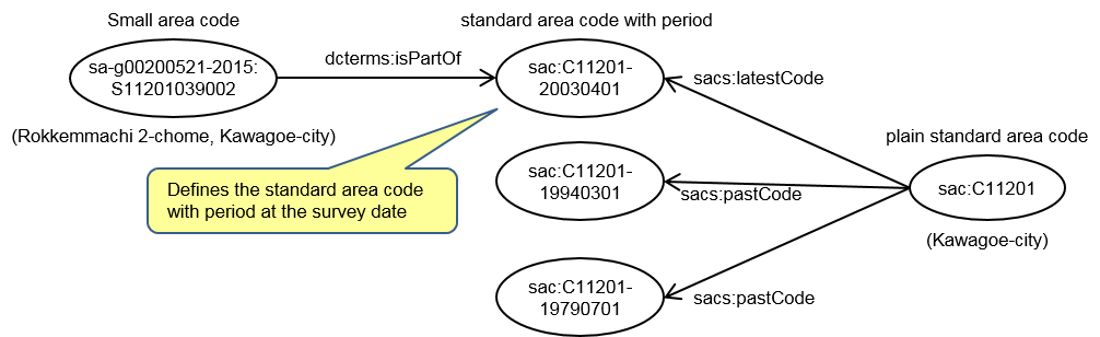
Standard area code without period is called "plain standard area code". Plain standard area code means latest or past standard area code with period. While standard area code is five digits, it is represented by C-<standard area code> in the statistical LOD of Japan.
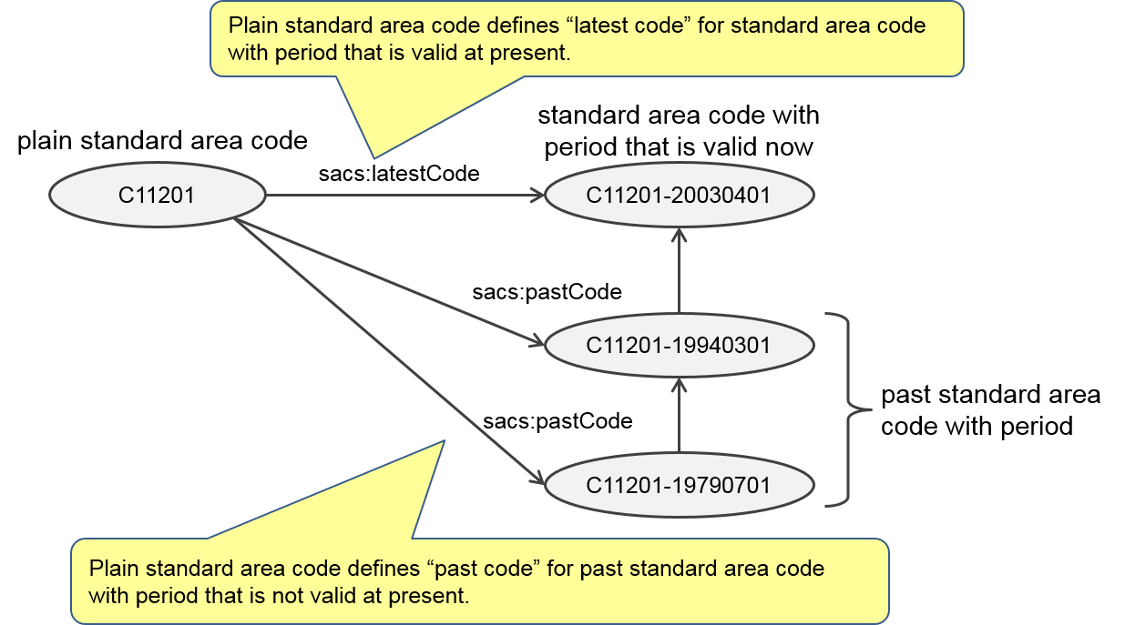
Each standard area code entity has corresponding municipality information and links to original and succeeding standard area code entity with period.
Reason for change entity has absorption or separation information and links to standard area code entities with period before and after change. For example, in case town changes to city, reason for change entity has two links to standard area code entities with period of abolished town and newly established city. In case boundary between city and town changes, reason for change entity has four links to old and new standard area code entities with period of city and town.
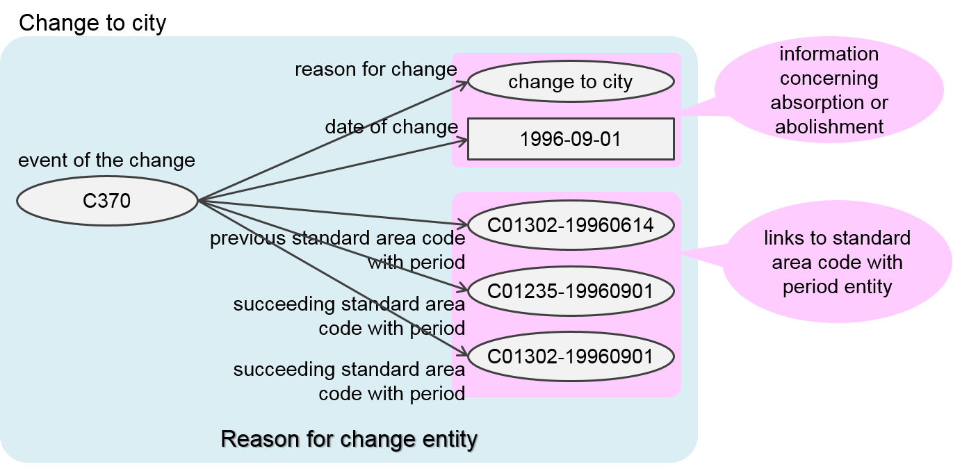
Relation of Standard area code entity with period and reason for change entity is as shown below using absorption and establishment of new Kasukabe-city.

Definition of administrative unit
Standard area code entity has administrative unit as information of municipality.

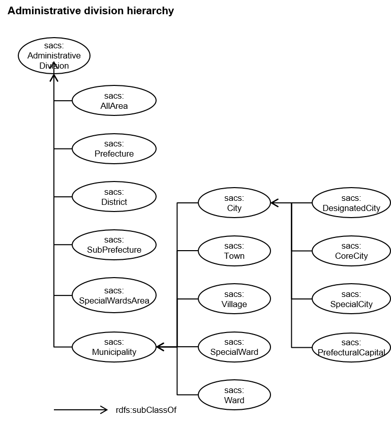
Administrative unit is divided into prefecture, special ward area, district, sub prefecture, city, town, village, ward, special ward, region, urban area, rural area, major metropolitan area and metropolitan area. Administrative units have hierarchy and aggregation relation. Relation between administrative units is as follows.
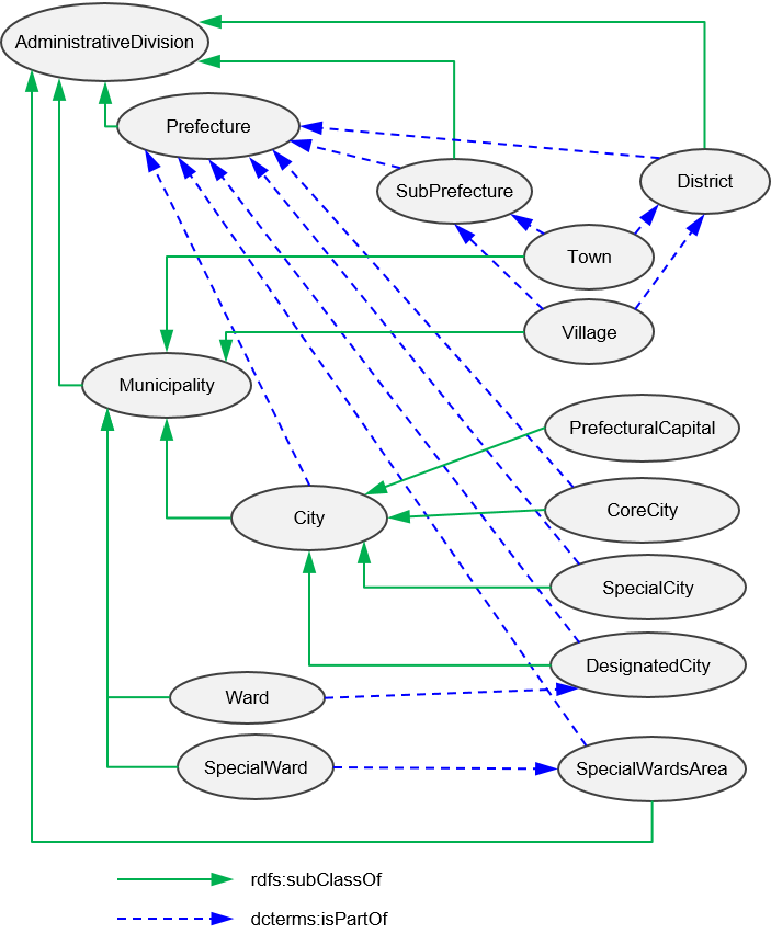
Hierarchy is defined for each administrative unit. Aggregation relation is defined for each standard area code with period. The data structure is illustrated below.
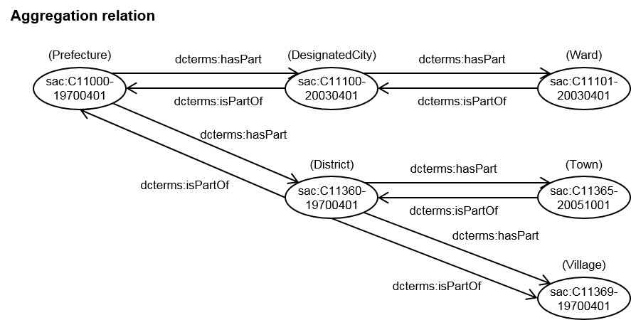
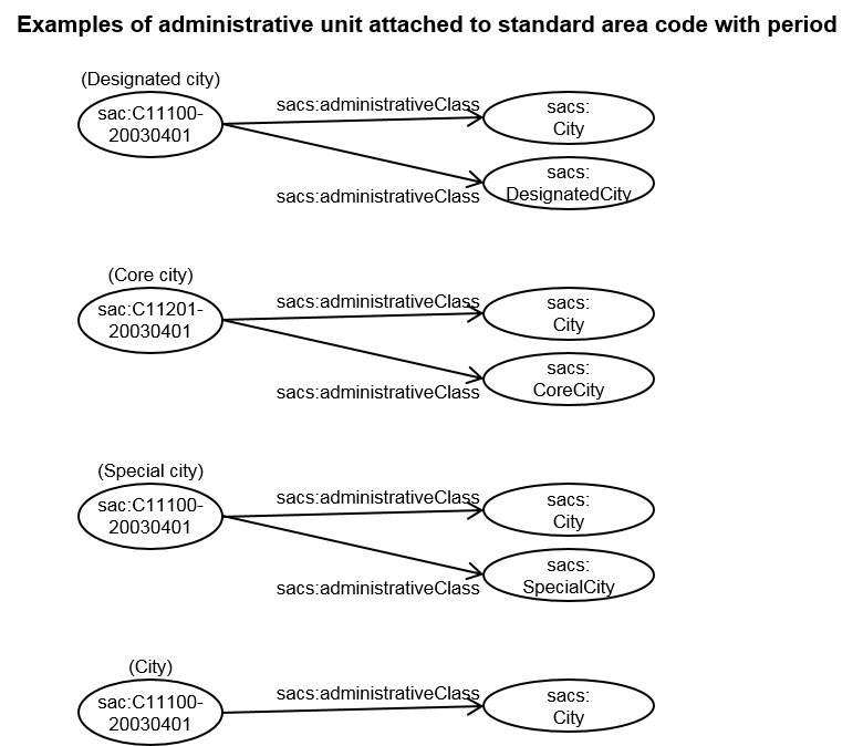
Administrative unit is attached to standard area code with period. In most cases, one administrative unit is attched to one standard area code. In case it is attached to designated city, core city, or special city, it is also attached to "city" that is parent class of designated city, core city, and special city.
Small area code, grid square code
Small area code
Outline of small area code
Small areas are subdivided portions of a municipal division.
Statistical LOD of Japan provides small area code used in 2015 population census.
Number of digits of small area code
- 1st through 5th digits show municipality code.
- 6th through 9th or 11th digits show sub-municipality code.
Examples
012020310 Minato-cho
01202031001 Minato-cho 1-chome
01202031002 Minato-cho 2-chome
* Statistical LOD of Japan adds “S” at the beginning of codes.
Definition of small area code
Small area code defines belonging municipality and geospatial information such as polygon data as well as name of the small area.
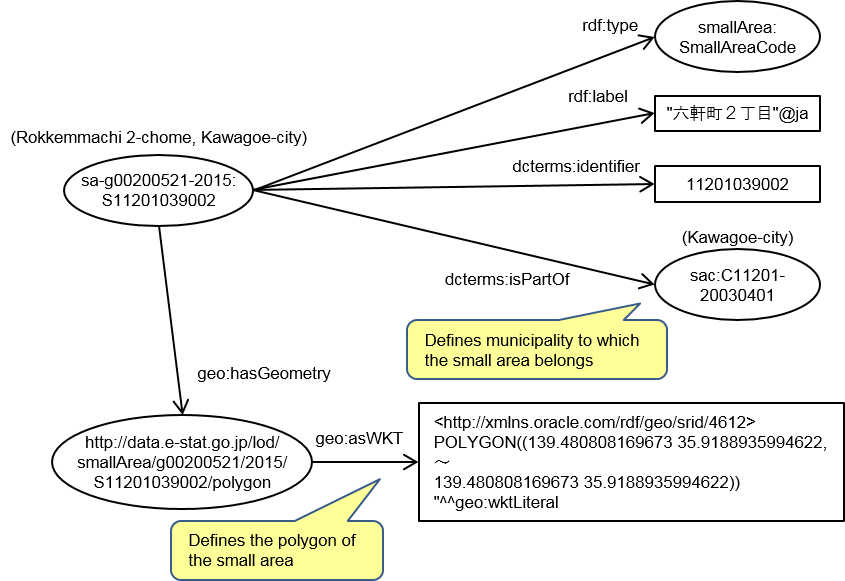
Standard area code with period at the survey date is used for belonging municipality.
Grid square code
Outline of grid square code
Grid squares are portions of the country divided into a grid by longitudinal and latitudinal lines.
Grid square code used for statistics are based on JISX0410 (Japan Industrial Stadards).For further information, refer to grid square statistics http://www.stat.go.jp/english/data/mesh/index.html
Statistical LOD of Japan provides three kinds of grid square codes, 3rd grid suare code, 4th grid square code, and 5th grid square code.
3rd grid squares are squares, 1km each side.
4th grid squares are squares, 500 meter each side.
5th grid squares are squares, 250 meter each side.
Statistical LOD of Japan uses world grid square code for global usage as JISX0410 covering area is limited. In world grid square code is, digits “20” are added at the beginning of JISX0410 code.
Number of digits of world grid square code
- 1st and 2nd digits are “20”.
- 3rd through 10th digits shows 3rd grid square code.
- 11th digit shows sub-square ID number by dividing 3rd square grid into four equal sub-squares.
- 12th digit shows sub-square ID number by dividing 4th square grid into four equal sub-squares.
Examples
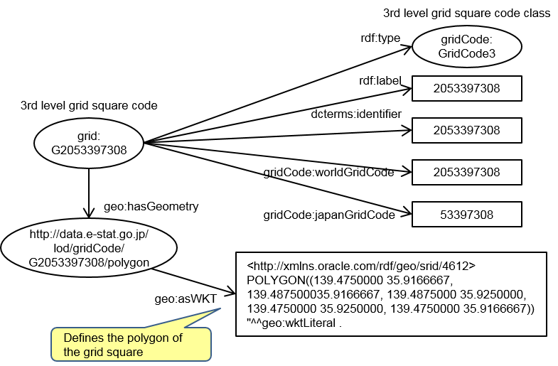
Third level grid square code : 2052350001
Fourth level grid square code : 20523500011
Fifth level grid square code : 205235000111
* Statistical LOD of Japan adds “G” at the beginning of codes.
Definition of grid square code
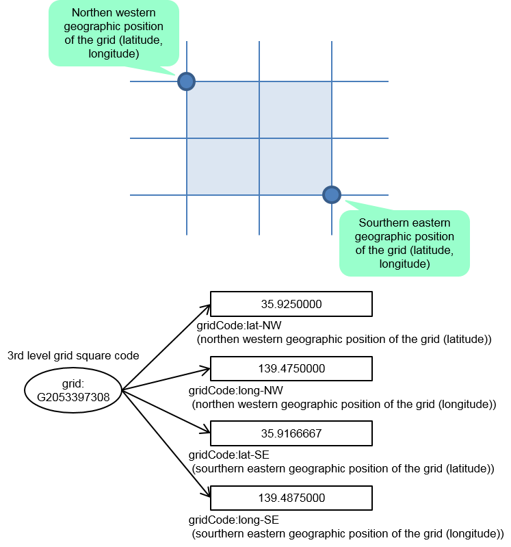
Grid square code defines geospatial information such as north-west point, south-east point and polygon data.